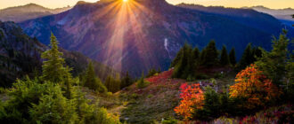
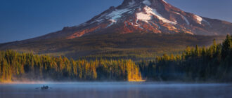
East Saint Marys Peak
East Saint Marys Peak, elevation 9,425 feet, is located on the southern side of Mission Mountains in northwestern Montana, about 28 miles from Missoula and 8.5 miles from Saint Ignatius. The Missions are massive mountains, famous for the western wall sharply rising from 3,000 feet to more than 9,800 feet and are fairly inaccessible, with several glaciers and a lot of wildlife. Saint Mary’s is one of the very few peaks in the Missions that can be climbed in the winter as there is low danger of avalanche. The road to the trailhead is often passable in winter due to its low elevation. The most commonly used southeast ridge route is considered very safe and is used for winter training by the New Rocky Mountaineers climbing club. Most of the western end of the Mission Mountains are part of the Flathead Indian Reservation and you will need a Reservation Hiking Permit.
Gray Wolf Peak
Gray Wolf Peak, elevation 9,001 feet, is a major peak in the southernmost end of Mission Range. This magnificent mountain’s true peak is not visible if you approach it from the north or west. Approaching from the south, as you enter the Flathead Indian Reservation, you see a distant, enticing view of the false summit. This is not a mountain for the inexperienced climbers and, while considered a non-technical mountain, it is not easy and far from straightforward, as you will have to find the right route among the few available. It is a good idea to choose a nice clear day to tackle Gray Wolf Peak in any case.
Appistoki Peak
Appistoki is located in Two Medicine Valley at the southeastern end of Glacier National Park. This 8,164-foot-high mountain is a part of the “Scenic Point Ridge Walk.” Appistoki Peak was named by topographer R. T. Evans, who worked on mapping the Glacier National Park. Appistoki is the word his Blackfeet guides used for “looking over something,” an Indian god who looks over everything and everyone. From Appistoki Peak, the view of Two Medicine Valley, the Nyack Region, and the Plains of Central Montana is spectacular. There are three possible routes to reach the peak: The Appistoki Creek Route, which runs from a sharp switchback on the Scenic Point Trail following the creek; the Scenic Point Ridgewalk trail, which takes about 10 hours and crosses several unnamed peaks; and from the south shore of Two Medicine Lake as well as from the Scenic Point Trailhead if you don’t mind some off-trail bushwhacking. Climbing Appistoki is possible all year round, but the strong winds can reach speeds of 100 miles per hour.
Grizzly Mountain
Grizzly Mountain, elevation 9,067 feet, is located in the Two Medicine area of the Glacier National Park and can be reached via a well-marked and well-maintained trail. It is necessary to leave the trail for the last 1.5 miles before the summit, although it is not really a difficult climb. It is 11 miles from trailhead to summit with a scramble through some truly magnificent mountain wilderness. The reward at reaching the Two Medicine Pass are views that will take your breath away. The area is not heavily trafficked and not as popular as Many Glacier. It has decent facilities and a campground and is a point for excursions on Two Medicine Lake.
Kupunkamint Mountain
Kupunkamint Mountain has an elevation of 8,797 feet and is located in the Lewis Range, in the southeastern part of Glacier National Park. There is a solid network of well-maintained trails, but they will take you only so far; the rest is a certain level of bushwhacking and game trails or no trails at all. On the lower slopes, dense forest and thick undergrowth will slow your progress and present you with confusing options, especially on the way down. Kupunkamint has no official trailhead, but the place to begin is at the entrance to Glacier National Park off the gravel road to the Cut Bank Campground. About half a mile further into the park is the ranger station, and after another half mile is the campground.
Painted Tepee Peak
Painted Tepee Peak, with an elevation of 7,650 feet, is also known as the Painted Tepee. It sticks out from the ridgeline between Chief Lodgepole Peak and the Two Medicine Pass. It can be clearly seen from the gorgeous Two Medicine Lake. From the summit, the vista stretches in all directions and includes Two Medicine Lake, Rising Wolf Mountain, Mount Ellsworth, Grizzly Mountain, Chief Lodgepole Peak, Mount Rockwell, Vigil Peak, and Sinopah Mountain. The mountain is a hikers’ delight, with an easy hike all the way to the summit with its pinnacles and outcrops. They require some serious scrambling to climb and, for climbers, are the highlights of the whole trip. Two Medicine Lake is one of the windiest places in the park. You can cut a bit of distance by taking the boat trip across Two Medicine Lake.
Ajax Peak
Ajax Peak straddles the Continental Divide and is located in the northern part of the Beaverhead Mountains. The closest towns are Salmon in Idaho and Wisdom in Montana. Over 10,000 tall, it can be easily seen from Idaho. The Ajax Lake basin had a colorful past, with the famous Ajax Mine on the south side of the basin just below the peak. The entrance to the mine shaft can still be easily seen once you gain some elevation. There is a rough road leading visitors to it. There is also a charming old cabin as you get closer to the lake. The other dominant feature of the mountain are the many charred barren trees still standing after a fire, covering a good portion of the lower slopes of Ajax Peak.
Rocky Mountain
Located in the Sawtooth Range, a part of the spectacular Rocky Mountains Front, Rocky Mountain, at 9,392 feet, is the heart of the Bob Marshall Wilderness. The Bob Marshall, the Scapegoat, and the Great Bear form a vast, wild, and rugged area popularly known as “The Bob.” Rocky Mountain is the place where climbers and hikers go when they want to be alone with spectacular natural beauty, with more chance of meeting a grizzly than other humans. The views while hiking open in all directions: Sawtooth Range, the Great Plains and, far on the horizon, Mount St. Nicholas and the Two Medicine area. The trailhead for Headquarters Creek Pass is located at the Mill Falls campground.
Mount Rearguard
Located in Beartooth Mountain Range, at 12,204 feet, Mount Rearguard is the highest peak on the huge Hellroaring Plateau. It can be accessed from many directions, and some of the easiest routes are just off-trail hikes. During the winter and spring, Rearguard offers some great ski descents. The most commonly used trailhead is the Rock Creek trailhead. There are several routes up the mountain, and you can pick the level of difficulty you want. There are a few great camping places that are easily accessible by car from the Rock Creek Road, or you can enjoy one of the National Forest campgrounds. If you prefer backcountry camping, you will enjoy the campgrounds on the shores of Shelf Lake and Moon Lake.
Gash Point
Gash Point, elevation 8,886 feet, is located in the Bitterroot Mountains near Victor, Montana. The mountain is not well known or used by hikers or mountaineers, so the trail is not maintained. That means a bit of roughing it, but also a pleasant solitude. Things are very different in the winter. Gash Point is one of the Bitterroot’s best and most popular back-county ski areas. Gash Creek and Gash Point got their name after a certain Jim Gash, who lived along the creek in the early 1870s. In 2006, a massive fire destroyed over 8,500 acres of forest. One good result was that the fire also burnt the dense undergrowth that had made hiking to Gash Point difficult. The trees are growing back and animals have returned as nature is reclaiming its territory. Keep in mind that after a few hundred yards on the trailhead, you will enter the Designated Wilderness, with the specific wilderness rules.
Tinkham Mountain
Tinkham Mountain, elevation 8,442 feet, is located in the Lewis Range of Glacier National Park. The trail starts at the Two Medicine Campground, and is about 21 miles on a round trip. The trail is good in most parts until you reach the last mile. The Goat Trail leads around the upper reaches of the mountain with exposed cliffs, gaining 3,279 feet in elevation. You will cross the Continental Divide at Cut Bank Pass and lose about 700 feet of elevation. The trailhead is located off the Two Medicine Campground. The starting point of several available trails is right after crossing the bridge. On the way to Tinkham Mountain you will cross two passes: Cut Bank and Pitamakan.
Mad Wolf Mountain
Mad Wolf Mountain, elevation 8,341 feet, is located in the Lewis Range in Glacier National Park, west of the Blackfeet Indian Reservation, rising sharply above the Great Plains. And that is the biggest allure of climbing this mountain, where the eastern windswept face meets the prairies. The jagged landscape, scoured by glaciers, changes rapidly into the endless fields of grass and soft rolling hills of the Great Plains. The views from the summit of Mad Wolf are vast and spectacular. You can see the Sweet Grass Hills rising more than 3,000 feet from the surrounding flat prairies. Also, the tree line is fairly low, so you will have unobstructed views early on at low elevations. There is plenty of wildlife – bears, mountain goats, and bighorn sheep. The most-used trailhead is near Cut Bank Campground. There is also a network of gravel roads through the Blackfoot Reservation that will take you to the top of Cut Bank Ridge, but you need a Blackfoot Recreation Permit.